


A powerful 7.4-magnitude earthquake struck off Indonesia’s Ternate in the North Maluku province, killing at least one person and prompting a tsunami warning that was later lifted.
Authorities reported building damage and urged residents in coastal areas to prepare for evacuation.
The United States Geological Survey (USGS) confirmed the quake at a depth of 35 km (22 miles), initially reported at magnitude 7.8. The epicentre was located approximately 120 km (75 miles) from Ternate, in the Northern Molucca Sea.
Local authorities in Ternate, Tidore, and surrounding cities immediately alerted residents, with preparations underway for possible evacuations.
Casualties and damage
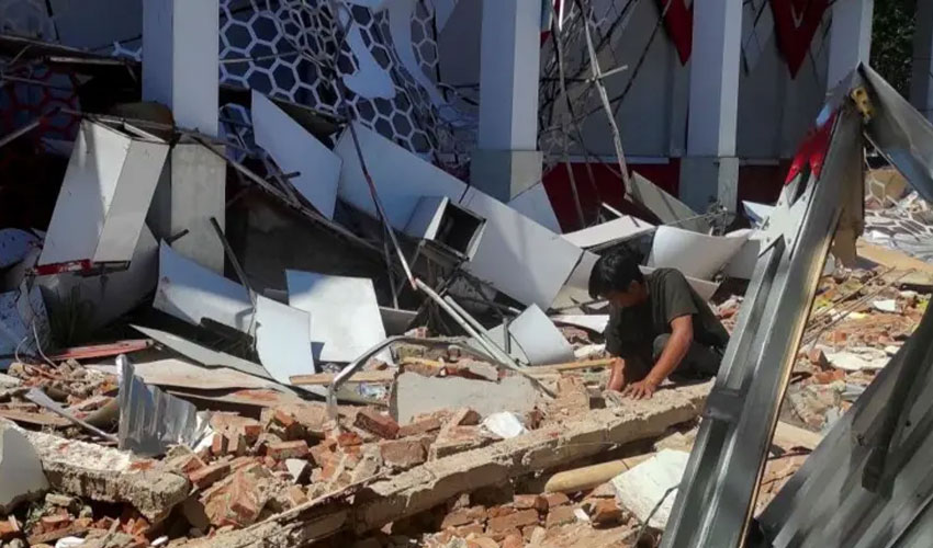
In North Sulawesi’s city of Manado, one person died and another sustained a leg injury when a building collapsed, according to George Leo Mercy Randang, a local search and rescue official. Victims were reported trapped under rubble, highlighting the quake’s severity in densely populated areas.
News channel Metro TV broadcast images showing damaged buildings, further illustrating the quake’s impact on local infrastructure.
Tsunami warning and observed waves
The Hawaii-based Pacific Tsunami Warning Center (PTWC) initially issued warnings for hazardous tsunami waves along Indonesia, the Philippines, and Malaysia within 1,000 km (621 miles) of the epicentre.
Within 30 minutes, the BMKG geological agency recorded waves up to 75 cm in North Minahasa and 20 cm in Bitung on Sulawesi island. North Maluku province saw 30-cm waves.
After monitoring the situation, PTWC lifted the tsunami warning just over two hours post-quake, declaring the threat had passed.
Indonesia lies on the Pacific Ring of Fire, an area of intense tectonic activity where earthquakes and volcanic eruptions are common. The region’s position at the junction of multiple tectonic plates makes it highly prone to seismic events.